Shturman icon: a navigation arrow over a blue and yellow horizon

Shturman

Guides you when GPS is jammed.

Turn-by-turn navigation for driving and walking. When satellites disappear or report a position in another city, Shturman notices, ignores them, and keeps moving you along the route using the phone’s motion sensors.

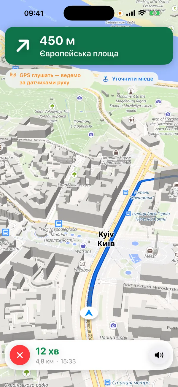
Shturman guiding without GPS: “450 m, Yevropeiska Square” and the route on a map of Kyiv

How it works without GPS

A shturman is a ship’s or aircraft’s navigator who works out the position by calculation when there are no landmarks. The app does the same when satellites are jammed.

  1. Notices the problem

    When the GPS signal disappears, or suddenly puts you in another city or country, Shturman detects it and stops trusting the satellites.

  2. Works it out

    In the car, your position moves along the route at the road’s planned speed, only while the phone says you are in a vehicle; the gyroscope picks up turns. On foot it uses your steps and the phone’s heading.

  3. Corrects itself

    As soon as GPS returns, the position is corrected. If you turn off the route without GPS, the app asks “Are you on … now?”, and you can always drag the map under a pin to set your position (“Set my position”).

Blue marker: position from GPS. Orange marker: estimated, so you always know when the position is calculated rather than measured. The estimate drifts with distance: it is a driving aid, not a guarantee.

What Shturman does

Alerts and shelters

Air-raid alerts by oblast and for Kyiv: a red banner, a short voice message, and a warning when a route crosses an oblast under alert. 32,000 shelters are built into the app, so the nearest one is found without internet, and one tap builds a route there.

Blackout layer

6,700 places that work without grid power: Invincibility Points (Пункти незламності), fuel stations and pharmacies with generators, and bank branches on the National Bank’s POWER BANKING list.

Offline maps

Download the map of your region and it displays without internet. Building a new route still needs a connection for now.

Trip summary

After every trip: distance, time, distance driven without GPS, how far off the position was when GPS returned, and fake-GPS events. Share it if you like.

Home, Work and Siri

Search with history, Home and Work, and press and hold the map to route anywhere. On iPhone, ask Siri to take you home, to work or to the nearest shelter. On Android, the same three are launcher shortcuts.

CarPlay and Android Auto

Android Auto on Android 10 and later. CarPlay on iPhone once Apple approves the app for CarPlay navigation.

Dark map at night

The map turns dark after sunset where you are and light by day. Voice guidance in Ukrainian or English.

Privacy

Your positions, sensor data, trips, Home and Work and search history stay on your phone: we have no server and no accounts. To show the map, find addresses and build routes, the app calls open services (OpenFreeMap, Photon, Valhalla) without any device identifier. No ads, no analytics, no tracking, and no data is sold. Privacy policy

Frequently asked questions

What is the difference between jammed and spoofed GPS?

Jammed means there is no signal at all and your position freezes. Spoofed means the phone receives fake coordinates and puts you in another city or country. Shturman detects both, ignores the bad data and keeps going on the motion sensors. Fake-GPS events are counted in the trip summary.

How accurate is navigation without GPS?

Dead reckoning drifts with every kilometre. The app shows that uncertainty and turns the marker orange, and corrects the position as soon as GPS returns. It is a driving aid, not a guarantee: follow road signs.

Does Shturman work offline?

Partly. Downloaded offline maps display without a connection, and the nearest shelter is found without internet. Building a new route still needs internet today; offline routing is planned.

What if I leave the route without GPS?

In the car, Shturman notices the turn and asks “Are you on … now?” with the street name. You can also drag the map under a pin to set your position yourself.

Where do alerts, shelters and blackout places come from?

Alerts come from a public feed and may be delayed, so always follow official alerts. Shelters come from government open data (data.gov.ua), city portals and OpenStreetMap. Shelter and blackout data are snapshots: check the signs on site, as places can be closed.

What data does the app collect?

We collect nothing: there is no server, no account, no ads and no analytics. The third-party map, search and routing services receive only what each request needs (for example, a route’s start and destination). Details are in the privacy policy.

Does it work with CarPlay and Android Auto?

Android Auto, yes, on Android 10 and later. CarPlay will work once Apple approves Shturman for CarPlay navigation.